Flash floods that swept through the Nepal-Tibet border region on Wednesday have left scores dead and more than 1000 people missing. Here’s what we know so far, and what likely caused the disaster.
Nepal flash floods: what we know so far
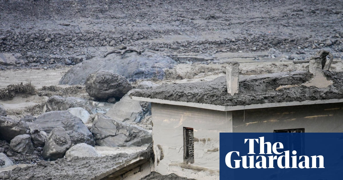
On Wednesday morning local time, a landslide of ice and rock resulted in a torrent of mud, water and debris bursting the banks of the Trishuli river, also known as the Bhotekoshi, which runs between China and Nepal. Homes, roads, bridges and power plants were swept away.
Officials in Nepal said 403 people, including 341 from foreign countries including India, the US, the UK, Australia, South Korea and Malaysia, had been reported missing. In Tibet, China’s state broadcaster said at least three people were killed and 265 were missing.
Experts at the Kathmandu-based International Centre for Integrated Mountain Development said water levels on the Trishuli river rose by as much as 9 meters in half an hour. The Lhende Khola river, a tributary of the Bhotekoshi, was most affected, they said.
“The Lhende Khola has flooded twice in 14 months, this time triggered by an ice rock avalanche from a glacier on the Nepal side that blocked the river and released a sudden surge downstream,” said Saswata Sanyal, a disaster risk reduction specialist at the climate research group.
What caused the flooding in Nepal?
An avalanche from a glacier is believed to be the likely cause of the flash flooding.
Local media reported Nepal’s foreign minister, Shisir Khanal, told the country’s parliament on Wednesday that initial reports suggested the floods could have been caused by an earthquake in the area that triggered a landslide.
However, the US Geological Survey (USGS) said that while the event was initially reported to be caused by a magnitude 4.4 earthquake, further analysis showed the “seismic event was a glacial collapse and debris flow that caused subsequent catastrophic impacts downstream” and “no earthquake had occurred”.
The USGS noted the glacial collapse had registered as a magnitude 5.2 seismic event on the Richter scale, occurring near the border between Nepal and China at 8.37am local time on Wednesday.
According to Assoc Prof Daniel Shugar, a geomorphologist at the University of Calgary in Canada, initial satellite analysis showed a 0.2 sq km chunk of ice “collapsed about 1.2km vertically”.
“What I can see in … satellite imagery from Planet Labs, the lower part of a glacier broke off at about 5,200 metres and crashed onto the valley floor about 1,200 metres below,” he said.
That was “likely enough to have converted a lot of potential to kinetic (heat) energy, melting the ice”, he wrote on Bluesky.
The satellite imagery also seemed to show that a large amount of snow had melted in the 24 hours prior to the disaster, he said. “Some of the glaciers in the valley were covered in snow yesterday and today they are mostly bare ice. So in other words (and I haven’t seen any weather station data yet), it was probably warm.”
Shugar said construction could also be a factor.
Prof Andrew Mackintosh, a glaciologist at Monash University in Melbourne, said it was unclear whether the collapse was isolated to the glacier, or was the “whole mountainside collapsing that included part of the glacier”.
“When a glacier of that scale collapses, it generates a lot of water, and then there’s a cascading sequence of events … where the water and the sediment combine and bulks up and creates the flood.”
An international group of glacier researchers has said that while a glacial collapse was “certainly involved”, it was “unlikely to be the sole cause”.
How often do glaciers collapse – and is the climate crisis a contributing factor?
“These sorts of large glacier collapses are really shocking,” Mackintosh said. “It’s hard as a glaciologist not be alarmed by these events that seem different to what we’ve observed previously.”
However, he said “there have been so few of these documented that we’re not really able to make very clear statements about the specific relationship between glacier collapse and climate change yet”. Scientists do, however, “have very high confidence in the relationship between glacier retreat and climate change”.
“We also know that mountain permafrost is degrading under a warming climate,” Mackintosh added. He described permafrost, ground that is frozen year round, as being akin to a “glue that holds the rock and sometimes adjacent glaciers … together on very sleep slopes”.
The Himalayas – spanning Nepal, India, China, Bhutan, and Pakistan – are warming twice as fast as the global average, putting the region at increased risk of avalanches, landslides and floods.
The United Nations said in 2023 that Nepal’s mountains had lost close to one-third of their ice in just over 30 years due to global warming. An assessment published that year found that Hindu Kush Himalayan glaciers disappeared 65% faster between 2011 and 2020 than in the previous decade.
In 2021, a Himalayan glacier broke off and caused flash flooding in the Indian state of Uttarakhand, leaving 200 people dead or missing. Subsequent research suggested that a 27m-cubic-metre avalanche of rock and glacier ice transformed into “an extraordinarily large and mobile debris flow”.
Though not thought to be a cause of the August 2026 event, mountain areas are also at risk of “glacial lake outburst floods”.
Glacial lakes form behind natural dams as a result of glacier melt, and can cause catastrophic outburst floods if their natural dam walls breach.
Assoc Prof Adrian McCallum, a glaciologist and polar engineer at the University of the Sunshine Coast in Australia, said: “With a warming climate, glaciers recede, ice becomes water, that water gets trapped.”
More than 12,000 deaths have already been attributed to such floods globally. According to the UN, Nepal has more than 2,000 glacial lakes, of which 21 are considered potentially dangerous.